
Guatemala
Feb 10th - 15th & Feb 28th, 2020

This is the first in a series of blogs about my latest adventure, a month long trip through Central America. I had originally planned to travel for seven weeks and visit all seven countries in the region, but unfortunately my trip was cut short by the Corona virus (more on that later). But I still managed to visit five new countries, the first of which was Guatemala. I had my wonderful friend Lara join me for the first six days. We left New York together very early in the morning on a United flight with a stop over in Houston, that got us into Guatemala City mid-afternoon. All countries in Central America (with the exception of Panama) share the same time zone, which is equal to US central time. Immigration was very quick and easy. Citizens from the US, EU and many other nations can enter Guatemala without a visa for up to 90 days.
We had decided to skip Guatemala City and were picked up at the airport by a driver from the hotel for the 1 hour trip to the city of Antigua Guatemala, our base for the first two days. We stayed at the stunningly beautiful Casa Santo Domingo Hotel, which is inside a ruined convent and also functions as a museum.


Antigua Guatemala
Antigua Guatemala served as the capital of Guatemala from 1543 to 1776. At that time Spanish Colonial Guatemala included almost all of Central America and the southern parts of Mexico. After a devastating earthquake in 1773 destroyed much of city, the capital was moved to present day Guatemala City. As a result Antigua has remained largely unchanged for 250 years, and is now a beautifully restored authentic example of Spanish Baroque colonial architecture. The city was laid out in a grid of 8 avenues and 8 cross streets, and all of them are paved with cobble stones.

Lara had arranged a photo tour with a local photographer for the morning of our first day. We met Rudy from Rudy Giron Photography at 8 am at a cafe next to the main plaza. He gave us a short introduction and then took us on a 3 hour walking tour through the city, where he showed us many of the best spots and angles. I learned a lot about composition and exposure settings from Rudy, and even discovered new things about my own camera.


Rudy was particularly focused on showing us the best framing shots in the city.

Antigua is a small city with a population of 35,000, which is only about half of what it was in the 17th and 18th century. Because of its importance for over 200 years, the city is full of many large and opulent churches and monasteries, many of which were built by eminent architects that came over from Spain and Italy. Almost all of these splendid buildings were destroyed by the earthquake. Most of them have not been rebuilt, and there are these grand and hauntingly beautiful ruins dotted all over the city.


A few of the churches did survive the earthquake or have been beautifully restored, such as the Iglesia de la Merced (left) and the Iglesia San Pedro Apostol.


The most famous landmark in the city is the yellow arch of El Arco de Santa Catalina, built in the 17th century. It used to connect the cloisters of Santa Catalina to the convent's school, and allowed the nuns to pass between the two without going out on the street.

The city is surrounded by several huge volcanoes, such as the Vulcan de Agua, which provides a dramatic background to many shots. The nearby Vulcan de Fuego is currently very active, and it belched out big clouds of smoke every 20 minutes or so. We didn't see it, but apparently on clear nights the red glow of lava is often visible from the city.


Based on Rudy's recommendation we walked up to the Cerro de la Cruz lookout point after lunch, which was a 30 minute walk from our hotel. We had a great view over the entire city and the Vulcan de Agua in the background, despite the fact that it was quite hazy in the afternoon.

One very typical and distinct sight in Guatemala are the very colorful chicken buses. They are called chicken buses, because people often bring their livestock with them on the bus on their way to the market. Each of them is painted differently, but always in very bright colors.

Because we did not nearly get to see everything on our first day with Rudy, we decided to book him again for another session the next morning. We got out even earlier to catch more of the morning golden hour, in order to get shots in the perfect light with interesting shadows.

Rudy took us to many more interesting spots for photos. And among other things, I learned about the importance of triangles in creating better compositions.


Our last stop for the day were the beautiful ruins of the Convento Santa Clara, a monastery for nuns, built in the early 1700's. The arcades around the courtyard are fairly well preserved, and so are the impressive arches of the main church.


Antigua Guatemala was given Unesco World Heritage site status in 1979, and it was truly one of the most beautiful places I have ever been to. It seems time in this city suddenly stopped in the late 18th century. There isn't a modern building to be found anywhere.
Lake Atitlan
We left Antigua the next morning. We had arranged a driver through our next hotel, who picked us up at noon for the 2.5 hour drive west to Lake Atitlan.
Renowned as one of the most beautiful lakes in the world, Lake Atitlan, located in the Guatemalan highlands at an elevation of over 1,500 meters, is the deepest lake in Central America. The lake fills a huge ancient caldera and is surrounded by several large volcanoes - none of them currently active.


I had booked a couple of hiking and sightseeing tours through the hotel via e-mail in advance. So, the next morning we were picked up by our local guide Domingo at 8:00 am. After a short boat ride to the nearby town of Santa Cruz la Laguna, we started with a hike that took us through farm land and up a steep mountain slope. After about an hour we reached a lookout point high above the lake for some great views.


We walked down the same way, and then made our way along the shore to the next town.


From here we took the boat across the lake to the town of Santiago Atitlan, which is located in a small bay nestled between two enormous volcanoes, the Vulcan San Pedro and Vulcan de Atitlan. Santiago is quite a large and busy town. We visited the very lively and crowded local market and saw the preparations for the start of lent celebrations. This region of Guatemala is almost entirely populated by indigenous Mayan people. There are hardly any ethnic Latinos to be seen. Almost all the women on the streets wear the traditional and very colorful dresses.


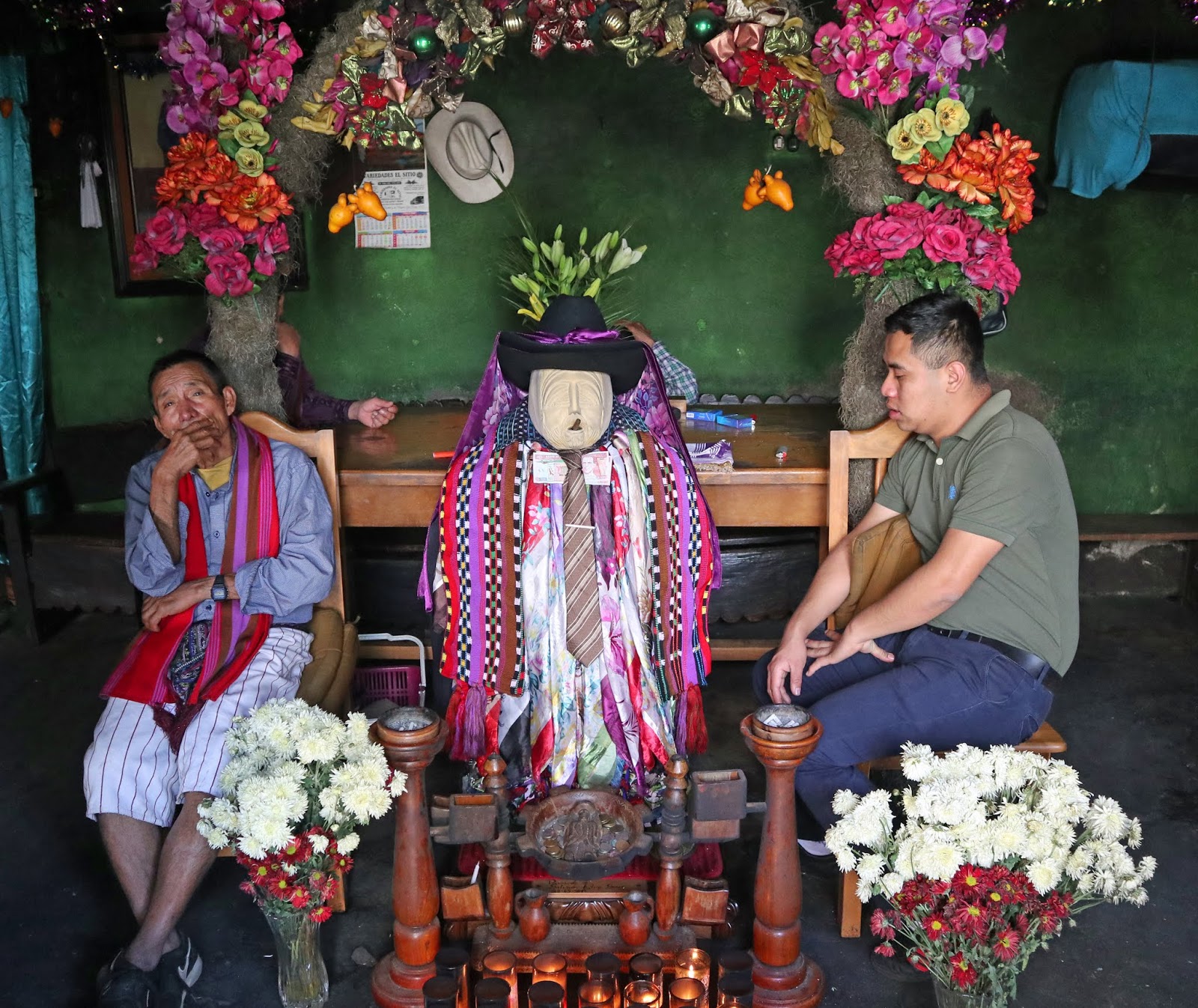
On our walk through town we noticed several elderly men in cowboy hats and colorful shorts sitting around. Domingo explained to us, that these are the so-called 'wise men' of the city. Apparently they are very important, and almost nothing can be done without their advice, which ranges from business to legal to marriage advice, and anything in between.

We also visited a slightly bizarre place - a small temple for a Mayan god, which also contained a life-sized glass coffin with a figure of Jesus Christ in it. When the Spanish conquistadors brought Catholicism to Central America in the 16th century, rather than giving up their Mayan religions, the local population just integrated catholic religious practices into their Mayan beliefs. And so they continued to worship Mayan deities alongside the new Christian god. The Mayan god here in the temple was represented by a small wooden statue wearing a cowboy hat and smoking a cigar. We learned that Mayan gods generally like a drink and a smoke, and they can be appeased by offerings of cigars and alcohol. After we made a small donation, they filled the statue with a generous portion of whiskey, and we felt a lot better having the Mayan god look after us for the rest of the trip.

After a strong Guatemalan coffee in a nearby cafe, we headed back down to the pier to find our boat, which took us to the town of San Juan la Laguna on the western shore. We had a very nice lunch in a local restaurant before heading out to check out the many art galleries here. San Juan is a much smaller and quieter town, full of little art and craft shops, most of which seemed to be run by the artists themselves.

We also had a demonstration by a Mayan lady on how to make yarn out of cotton (something we both tried and completely failed at), how to dye the yarn and how to weave the fabric on a loom wrapped around her back.


The last town we visited on our sightseeing tour was San Pedro La Laguna, which we reached by squeezing into a tuktuk, which can be found here everywhere.

The caldera filled by Lake Atitlan, was formed around 84,000 years ago. It is actually quite a bit larger than the current lake, since two large newer volcanoes grew out of the lake in the last 80,000 years. Guatemala lies within one of the most tectonically active areas on the globe. This is due to the Middle America Trench, which lies in the Pacific Ocean around 100 km offshore from the coasts of Guatemala, El Salvador, Nicaragua and Costa Rica. The trench is an active subduction zone where the Carribean plate meets the North American plate and the Cocos plate. It causes the so-called Central American volcanic arc, which stretches from Southern Mexico all the way down to Northern Panama and includes hundreds of active volcanoes and produces frequent and often major earthquakes.

An interesting phenomenon of the lake is that its water level can vary quite significantly over the course of several years or decades (sometimes much faster as happened in 1976, when an earthquake ruptured the lake bed, and caused the water level to drop by several meters in a month). That is the reason why most of the villages are built fairly high above the shoreline. Domingo told us that they only sell the waterfront properties to foreigners, who don't know better. We saw a hotel that had some balconies in the water, and when you take the boat into San Juan pier you can see foundations of several houses under the water.


We were picked up in the dark at 6:30 am the following morning by Domingo. We had a big hike planned and wanted to get an early start, in order to have clear views from the top. Mornings tend to be the clearest time of the day here, often haze starts to come at midday. We stopped for a quick breakfast in Santa Cruz, where we watched the sun rise over the lake:

We then headed over to San Juan again to start the hike up to La Nariz del Indio, which is a very sharp and steep peak on the crater wall of the caldera.


We started to walk just before 8:00 am and managed to get to the top in just under three hours. It was a really tough but absolutely stunning hike, that first took us through a forest and then through coffee plantations. The higher sections were very steep with big steps that required quite a bit of scrambling. But, the views from the top over the entire lake made the effort more than worth it.

After spending a bit of time to take pictures at the lookout on top, we continued down the other side to the town of Santa Clara, where we briefly stopped to see the colorful cemetery. It is a particular Guatemalan custom, to paint graves in very bright colors.


For the ride back Domingo had a special treat for us. He had booked a truck, so we could experience the way the locals travel. We were standing in the back of the open truck holding onto a metal frame, while the driver navigated the very steep switchback road downhill back to San Juan. From there even the boat trip back was a bit adventurous, since the wind had picked up and whipped the water into fairly powerful waves, that threw our little boat around. We had to hold on with both hands to stay in our seats. But we made it back safely, and finished the day with a lovely dinner and this view.

We left Lake Atitlan the next morning for the 3 hour drive back to Guatemala Airport, where Lara took a flight back to New York, and I continued on to my next Central American country, El Salvador. But, this is not the end of this blog post, because I came back into Guatemala two weeks later to see another very special site - the Mayan ruins of Tikal.
Tikal

The ancient Mayan city of Tikal is located in the north-eastern part of Guatemala - close to the border with Belize. To visit Tikal you can either fly from Guatemala City to the town of Flores, which is about an hour's drive south, or you can visit on a day trip from the town of San Ignacio in Belize, which is what I did. I spent four days in San Ignacio as part of my Belize trip (which I wrote about in a separate blog post), and I had booked a guided tour through my hotel there. I met with my guide and the other two people on the tour early in the morning for the 20 minute drive to the Belize-Guatemala border. We left the van there and walked through the border controls to meet our Guatemalan guide and driver on the other side. The guide from Belize came with us, but he was not permitted to guide in Guatemala. The drive from the border to the entrance to Tikal National Park took another 1.5 hours. We started at the visitor center, which is surrounded by lots of tourist shops and had an interesting 3D model of the whole complex.

The ruins of Tikal are hidden in dense rain forest and are the remains of one of the largest cities and most powerful kingdoms in the Mayan world. This is generally considered one of the two most important Mayan sites (the other one being Chichen Itza in Mexico). Tikal is enormous, the residential section of the city are estimated to cover an area of over 60 square kilometres. The whole area of more than 500 square kilometres surrounding the site, has been declared a National Park in 1955. While some of the structures date back as far as the 4th century BC, the city reached its peak during the late classical period in 700 to 900 AD. At its height, it is estimated that more than 100,000 people lived in the confines of the city, and another 300,000 in the surrounding area, which would have made it one of the largest urban centers in the world at the time.
We started our tour walking through the forest to the huge pyramid of Temple IV, which is not only the highest building in Tikal, but with a height of 70 meters (230 feet) it is the tallest pre-Columbian structure in the Americas.


There are wooden stairs built on the side that take you up to near the top of the pyramid. The view from up there was amazing, as you can see the tips of several other pyramids peeking out among the trees in the distance.


The so called 'Mundo Perdido' (or Lost World) complex contains the oldest remaining structures in Tikal. It consists of a series of pyramids and other buildings, which were mostly used for astronomical observations, particularly the cycles of Venus and the Sun, as well as the solstices and equinoxes, which all played important roles in the Mayan calendar.


Just as most other Mayan cities, Tikal experienced a significant decline in population by the end of the classical period around 900 AD, and the city was completely abandoned by the end of the 10th century. The exact reasons for the decline of Mayan civilization are still being discussed among scholars, but it was most likely due a combination of overpopulation and environmental changes causing a decline in agriculture. The buildings were left to be consumed by the jungle for over 900 years, before being rediscovered in the mid 1800's. But due to the extreme remoteness of the site in the jungle, major excavations were only undertaken in the 20th century. There are thousands of structures and monuments at Tikal, and only a small fraction of them has been excavated and reconstructed. This is what an un-excavated pyramid looks like:

While we were walking through the monuments, we saw a lot of these little animals running around the ruins, and particularly near the picnic areas. They are Coatis, which are closely related to raccoons. They can be quite bold, and steal your sandwich of the table if you don't watch out.

Even though Tikal is now a major tourist attraction, due to its size it never felt crowded. You can easily find yourself alone among these mysterious structures hidden among the trees. The whole site has an eerie lost world feel to it.

All the structures were built of local limestone which was quarried on site. The quarries were then turned into water reservoirs. Tikal had no lakes, rivers or other natural water sources, and all of the city's water needs where met by rain water collected in these giant reservoirs.

Our guides left the best part for the end. Our last stop was the most impressive section of the whole complex - the Great Plaza, which is surrounded by monumental temples, palaces and burial buildings. The plaza is flanked on either end by two tall temple pyramids, and on its south side lies the enormous palace complex of the Central Acropolis.


This 180 degrees panorama shot provides a small glimpse of the majesty of this place. It is difficult to imagine what life would have been like here 1,200 years ago, and the wealth, power and level organization required to construct monuments like these.

This is the iconic Temple I, a beautiful and slender pyramid with a height of 45 meters. It was built around 740 AD as a mausoleum and contains the tomb of king Jasaw Chan K'awil.


Tikal National Park was given Unesco World Heritage dedication in 1979. It is truly one of the great archaeological monuments in the world. The age, grandeur and beauty of its temples, palaces and public squares provide a real sense of what an incredible and sophisticated civilization lived here more than a thousand years ago.
We returned back to Belize in the early afternoon, where I continued my trip through Central America. This ended up as one of my longer blog posts, but that is because Guatemala really was one of the most beautiful countries I have visited. Each of the three sights alone - Antigua, Lake Atitlan and Tikal - would have been worth a trip half around the world.
No comments:
Post a Comment